Lesson 6: Soil Erosion and Sediment Control Policy and BMP Mapping
Learner Outcomes
Students will work as a team to decide which best management practices are suitable for different construction or agricultural sites depending on a given scenario. Students will explore the different state and national regulations that guide their decisions.
Success Indicator
Describe policies that mandate erosion and sediment control.
Skill Level
Advanced; ages 14-18
Time Needed
One, 90-minute class or two 45-minute classes
Life Skills
- Decision Making
- Problem Solving
- Communication
- Conflict Resolution
- Empathy
Materials
- Scenarios for BMP Mapping (print, at end of the lesson)
- Laminated construction site maps (download maps from www.growforit.org and print at local printing store at poster size) or map created by websoil survey.
- Dry erase markers (several different colors)
- Lesson 6 slides
Lesson Slides
Lesson Slides
Click on “File” and then select “Make a Copy ” of the lesson slide deck to use it with your youth.
Introduction
Background Information
Regulations and Policies
Established in 1972, the federal Clean Water Act protects surface water quality in the United States. The Clean Water Act is intended to restore and maintain the chemical, physical, and biological integrity of the nation’s waters for “the protection and propagation of fish, shellfish, and wildlife and recreation in and on the water” (EPA, 2010). A variety of regulations and best management practices have been created to reduce direct pollutant discharges, like sediment, into waterways. States have further developed policies that regulate practices that disturb the land from construction, agriculture, logging, mining, and emergency activities.
As part of the federal Clean Water Act, states were mandated to either create their own soil erosion and sediment control legislation or adopt the Environmental Protection Agency’s Clean Water Act policy. For example, North Carolina chose to create the Sedimentation Pollution Control Act (SPCA) of 1973 to prevent sediment from reaching state jurisdictional waters and mandating the use of sediment and erosion control measures during land-disturbing activities. The SPCA’s main goals are to keep sediment from entering waterways and to keep it from affecting adjacent landowners. To implement the goals of the SPCA, there are five main requirements (NC Riverkeepers, 2010):
- An erosion control plan is needed for any disturbed area greater than one acre.
- You must follow the erosion and sediment control plan as designed for your site.
- Erosion control measures must be implemented to prevent offsite or in-stream sediment.
- Some type of buffer must be present to prevent sediment from entering the stream (this is dependent on the specific stream).
- Ground cover/vegetation must be established within 21 days of the completion of any phase of grading (i.e. clearing and grubbing).
Developers are required to submit an Erosion and Sediment Control Plan for any land-disturbing activity on sites over one acre or more with the government or local agency that includes each best management practice they intend to employ. In NC, local agencies require levels of water quality to be maintained at certain turbidity levels. For example, trout streams may not have turbidity levels of more than 10 NTUs, lakes, and reservoirs 25 NTUs, and non-trout streams 50 NTUs. These levels are to protect the waters from degradation and loss of habitat. Failure to comply may result in penalties, leading to the cessation of construction and monetary fines.
Daily Blog Breakdown
Provide students a few moments to discuss the most recent blog posts. Ask them why it is important for people to know about turbidity, total suspended solids, and best management practices in erosion, sediment, and turbidity control.
- What information struck students as interesting or compelling?
- What did they find useful or informative that they didn’t know?
- How have blogging and reading blogs impacted their learning?
- How does social media play a role in gathering and processing information?
- How has this given them skills to interpret information?
Soil Erosion and Sediment Control Legislation
Understanding Policies
Put the following opening questions on the chalkboard and have students take five minutes to write down their ideas: What federal policy legislates states protect water quality? and Why are regulations important?
Begin by using the Lesson 6 Slides to discuss with the students the different regulations and policies that the federal and state governments have agreed upon as measures to protect water quality.
- Go back to the opening questions and ask the students why these regulations are important.
- Continue to facilitate discussion about the effects of policies on environmental protection, using the following questions as prompts:
- “Why do we need regulations in the first place?”
- “What impact do regulations like these have on landowners?”
- “What effects do these policies have on making land use decisions?”
- “Do you think that policies are an effective way to protect water quality?” “Why or why not?
- “What happens when regulations are not complied with?”
Legislation at Work
Have students work in small groups to create their own legislation that would mandate erosion and sediment control as part of any land-disturbing activities in their state. Use the “Legislation at Work” handout at the end of the lesson to guide their thinking and give them a piece of large paper to write down their final ideas.
- Give the students about 20 minutes to pull their policy together.
- Have students note the similarities and differences between groups. What makes sense? Is there anything that should or should not have been included?
- Encourage the students to debate about what should be included.
- Research whether your state has a local erosion and sediment control policy. If one is available, use this policy as part of your discussion with the students as they are sharing what they developed.
- In conclusion, ask the students if they thought the policy was important. Ask them if they can think of ways that policies affect other parts of their lives. They might think about school dress codes, off-campus lunch privileges, driving restrictions, and other laws. Do they think these laws are important? Why or why not?
Legislation at Work handout
Use this student handout to guide student understanding of soil erosion policies.
BMP Mapping
Student BMP Mapping
Transition the students back to focusing on how soil erosion and sediment control policies affect landowners’ management of the soil. The students will use a map and be given a land-use scenario and decide which practices they think need to be implemented on the map of their construction or agricultural site.
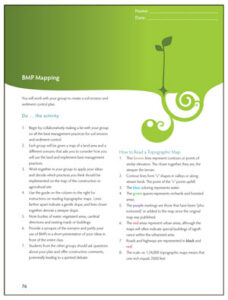
- Pass out the “BMP Mapping” student handout and explain to the students that they will be creating a soil erosion and sediment control plan.
- They will work together to make a list of best management practices for soil erosion and sediment control.
- Give groups the same map of a land area (printable maps at www.growforit.org or a map downloaded from websoil survey of the school campus or surrounding area, see the box below)
- Also, pass out a different scenario (in a tab in this section) to each group that will put their knowledge from the past week into practice. The scenarios vary, with some groups focused on maximizing environmental protection versus another group emphasizing cost-saving measures. The students should work together in their groups to apply their ideas.
- After the students have decided what BMPs to utilize, have them present their ideas in front of the entire class.
- They should briefly provide a synopsis of their scenario and justify their use of BMPs. Students from the other groups should ask questions about their plan and offer constructive comments, potentially leading to a spirited debate.
- As much as possible, incorporate regulatory policies as part of the discussion.
—————————————————————-
Web Soil Survey is a service offered by NRCS and allows you to enter your exact location/address. Define an Area of Interest (AOI) in the program to print out a map of the area. Also, use the information created to identify your specific soils and all properties related to them. Click on this link to explore soils in your area:
——————————————————
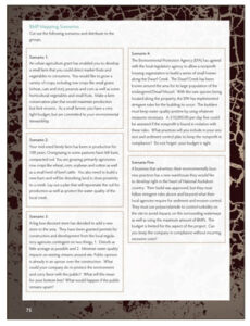
BMP Mapping Scenarios
Use these scenarios to guide each group in mapping their BMPs.
BMP Mapping Activity
Provide groups with copies of the BMP mapping instructions.
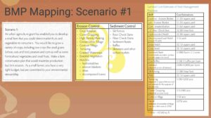
BMP Mapping Jamboard
Try this BMP mapping jamboard as a way to digitally map out BMP’s.
Talking it Over
Share… what you did
- Why is it important to understand soil erosion?
- How did you feel about soil erosion before these activities? Now?
Generalize… to your community
- How will learning about soil erosion help you in your life?
- How might you use your new skills at home?
- What are some situations when you will need to use the skills you have learned throughout this unit?”
Apply… to your community
As this unit on soil erosion wraps up, reflect on how the information you have learned is applicable in other ways in your life.
- “What did you like about the activities the past few days?”
- “What was your favorite way of learning?”
- “What skills did you gain as a result of this unit?”
- “Were there problems that came up over and over? Why? How were these resolved?”
- “What was hard about trying to participate in a group?”
- “How did this differ from the way you are usually taught in school?”
- “What did you learn about your own skills in making decisions?”
- “In what ways do other people help you learn new things?”
- “What do you feel like you need to work on to be effective in being a leader and communicating your ideas?”
- “What did you learn by participating in this process that will help you in the future?”
Assessment
Assessment
Rainbox Laboratory Write-Up (Final Blog Review)
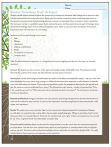
Have students work individually or in their groups to write a formal lab report on the Rainbox Throwdown. Teachers may choose to have students write their lab reports or submit them as a final blog posting. Give students the Final Lab Report handout on the next page to guide their writing.
Rainbox Throwdown: Final Lab Report
Use the student handout or the digital notebook for students to write their findings of the rainbox throwdown.
Chain Notes
Chain Notes (adapted from Keeley, 2011) begins with a question written at the top of a piece of paper and is then circulated from student to student. Each student, individually answers the question with one or two sentences and passes it to the next student. This student adds a new idea or builds upon a prior statement. Students can agree, disagree, extend a statement, and be encouraged to try to connect statements with the idea they are adding, but should not duplicate a statement. Chain Notes only should take one to two minutes per student and can be implemented when students are also engaged in other tasks like the Rainbox Final Lab write-up.
Chain Notes enables students to examine each other’s thoughts and compare them to their own ideas. As they examine the ideas listed, they must synthesize and evaluate what others have written before contributing their own. Students can draw from their various levels of knowledge including facts, definitions (word wall), specific or big ideas, experiments (Raindrop Splash, Rainbox, Soil Properties Lab), and other evidence from class experiences to create the chain.
Chain Notes can be used to check for student understanding of specific concepts and it allows teachers to know the depth of knowledge or misconceptions students hold.
Use Fig. 6-1 for an example of a chain note on erosion written by students.
What is soil erosion and sediment control?
|
Learn More
Learn More
Youth interested in leadership opportunities could consider forming or joining a local 4-H club that focuses on the environment. 4-H clubs provide a forum where youth peers can discuss issues that matter to them (for example, an eroded, muddy creek) and work together to solve problems with the facilitation of an adult leader. Youth can grow into positions of leadership within the club and learn the democratic process to make decisions. 4-H’ers often have citizenship opportunities where they attend county, state, and national legislative sessions and can observe or actively participate in policy-making. Youth can use the 4-H club structure as a place to find their voice and passion for understanding issues and ideas they want to learn more about. To find out more about 4-H, visit: 4-H.org


